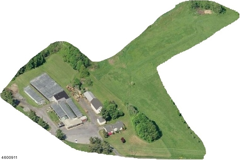
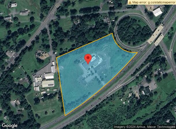
Property Record
Route 31, Ringoes, NJ 08551
NEARBY LISTINGS FOR SALE OR LEASE
Property Detail
Route 31
08-00009-01-00005
FACILITY NAME: ANIMAL SHELTER
Religious
Hunterdon
X
New Jersey
34019C0361F
5
0
7.70 AC
2024
Hunterdon
011305
Northern New Jersey
6,329 SF
Newark, NJ-PA
DEMOGRAPHICS near Route 31
1 Mile
3 Mile
5 Mile
2024 Total Population
669
4,502
14,627
2029 Population
670
4,523
14,667
Pop Growth 2024-2029
+ 0.15%
+ 0.47%
+ 0.27%
Average Age
45
45
45
2024 Total Households
258
1,674
5,472
HH Growth 2024-2029
0.00%
+ 0.42%
+ 0.29%
Median Household Inc
$105,288
$129,054
$133,610
Avg Household Size
2.60
2.70
2.60
2024 Avg HH Vehicles
2.00
2.00
2.00
Median Home Value
$478,845
$580,251
$574,319
Median Year Built
1971
1974
1979
Nearby Places
- Restaurants
- Banks
- Shops
- Fitness
- Groceries
PUBLIC TRANSPORTATION
AIRPORT
Trenton Mercer
DRIVE
WALK
Distance
Trenton Mercer
26 min
14.8 mi
Freight Ports
Port of Philadelphia
DRIVE
WALK
Distance
Port of Philadelphia
62 min
36.4 mi
SALE & LEASE HISTORY
LISTING DATE
SALE/LEASE

Sep 24, 2016
For Sale
Nearby Properties
Address
Land Use
TOTAL SIZE
Lot Size
Zoning
Address
Land Use
TOTAL SIZE
Lot Size
Zoning
53.62 AC
RR-5
Address
Land Use
TOTAL SIZE
Lot Size
Zoning
31.35 AC
VAL
Address
Land Use
TOTAL SIZE
Lot Size
Zoning
300.85 AC
VAL
Address
Land Use
TOTAL SIZE
Lot Size
Zoning
11 AC
VAL
Address
Land Use
TOTAL SIZE
Lot Size
Zoning
1,536 SF
29.11 AC
LI
Address
Land Use
TOTAL SIZE
Lot Size
Zoning
77.26 AC
AR-5
Address
Land Use
TOTAL SIZE
Lot Size
Zoning
12,978 SF
2.37 AC
A-1
Address
Land Use
TOTAL SIZE
Lot Size
Zoning
127.88 AC
VAL
Address
Land Use
TOTAL SIZE
Lot Size
Zoning
72.39 AC
AR-2
Address
Land Use
TOTAL SIZE
Lot Size
Zoning
540 SF
9.40 AC
LI
Address
Land Use
TOTAL SIZE
Lot Size
Zoning
10,084 SF
2 AC
VAL
Address
Land Use
TOTAL SIZE
Lot Size
Zoning
11,122 SF
2 AC
RR-6
Address
Land Use
TOTAL SIZE
Lot Size
Zoning
10 AC
HO
Address
Land Use
TOTAL SIZE
Lot Size
Zoning
11,594 SF
1 AC
VAL
Address
Land Use
TOTAL SIZE
Lot Size
Zoning
4,108 SF
28.33 AC
LHC
Address
Land Use
TOTAL SIZE
Lot Size
Zoning
12.62 AC
I-1
Address
Land Use
TOTAL SIZE
Lot Size
Zoning
3 AC
LHC
Address
Land Use
TOTAL SIZE
Lot Size
Zoning
5,236 SF
3.89 AC
LHC
Address
Land Use
TOTAL SIZE
Lot Size
Zoning
16,800 SF
1.60 AC
LB
Address
Land Use
TOTAL SIZE
Lot Size
Zoning
8,915 SF
1 AC
VAL
Address
Land Use
TOTAL SIZE
Lot Size
Zoning
7,339 SF
4 AC
SRPD
Address
Land Use
TOTAL SIZE
Lot Size
Zoning
1.69 AC
B-5
Address
Land Use
TOTAL SIZE
Lot Size
Zoning
10,619 SF
1.75 AC
VIL
Address
Land Use
TOTAL SIZE
Lot Size
Zoning
5,321 SF
2 AC
SRPD
Address
Land Use
TOTAL SIZE
Lot Size
Zoning
10,120 SF
1.80 AC
RR-5
Address
Land Use
TOTAL SIZE
Lot Size
Zoning
7,200 SF
1 AC
MTN
Address
Land Use
TOTAL SIZE
Lot Size
Zoning
7,520 SF
0.81 AC
VIL
Address
Land Use
TOTAL SIZE
Lot Size
Zoning
3.23 AC
LHC
Address
Land Use
TOTAL SIZE
Lot Size
Zoning
1,224 SF
7.36 AC
B-5
The World's #1 Commercial Real Estate Marketplace
Connect with us
© 2025 CoStar Group
The information above has been obtained from sources believed reliable. While we do not doubt its accuracy we have not verified it and make no guarantee, warranty or representation about it. It is your responsibility to independently confirm its accuracy and completeness. Any projections, opinions, assumptions, or estimates used are for example only and do not represent the current or future performance of the property. The value of this transaction to you depends on tax and other factors which should be evaluated by your tax, financial, and legal advisors. You and your advisors should conduct a careful, independent investigation of the property to determine to your satisfaction the suitability of the property for your needs.